Building or replacing a fence seems straightforward: you pick a design, hire a contractor and get started. Yet many Utah homeowners discover too late that their new fence crosses the property line or violates local ordinances. That mistake can trigger costly boundary disputes and even the forced removal of the fence. A boundary survey is a simple step that prevents these headaches by clearly defining your property’s limits before any construction.
What is a boundary survey?
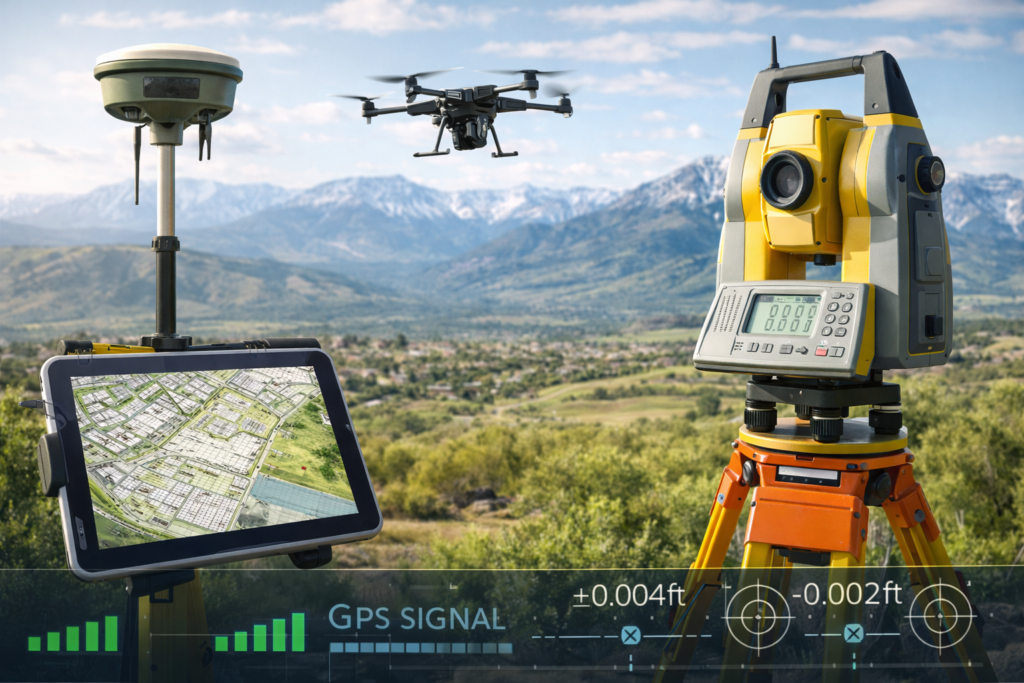
A boundary survey is an official measurement and mapping of a parcel of land performed by a licensed professional surveyor. Using legal descriptions from deeds and recorded plats as well as modern equipment like GPS receivers, total stations and measuring tapes, the surveyor locates and re‑establishes the corners of your lot. The resulting map (often called a plat) shows the exact property lines, dimensions and any encroachments. The surveyor may place wooden or iron pins at corners so you can physically see the boundaries.
Boundary surveys differ from mortgage inspections or informal “stake surveys.” A true boundary survey requires research into historical documents, verification of deed calls, and professional judgment to resolve discrepancies. That’s why Utah law requires certain projects, such as subdividing property, moving a lot line or filing a lot split, to be performed by a licensed surveyor. Simply having a contractor measure distances is not enough and could leave you liable for mistakes.
Why fences don’t prove ownership
Many homeowners assume the existing fence or a rock wall marks the property line. In reality, fences are often installed for convenience rather than legal accuracy. Over time, lines can shift as neighbors replace sections or avoid obstacles like trees. A Utah County surveyor FAQ notes that surveys are recommended before building a fence or other structures to prevent encroachments. An article for homeowners on United Fence’s website goes further, stating that the only reliable way to determine property lines is to hire a professional surveyor. Building a fence based on guesswork risks violating your neighbor’s rights or losing part of your own land.
Common reasons to obtain a boundary survey
A boundary survey is a prudent investment in many situations. Consider ordering one when you:
- Plan to install or replace a fence. Knowing the true boundary prevents placing posts on your neighbor’s lot and gives you evidence if a disagreement arises.
- Construct a garage, shed, driveway or pool. Setbacks and zoning rules are based on property lines; an accurate survey ensures your structure won’t encroach.
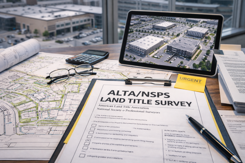
- Buy or sell property. Surveys provide transparency about the size of the land, existing encroachments and recorded easements. Real‑estate agents often recommend boundary or ALTA/NSPS surveys for high‑value transactions.
- Resolve a boundary dispute. If your neighbor claims a portion of your yard, a survey document can settle the argument or be used as evidence in court. Utah’s property‑rights office notes that disputes can be resolved by agreement or litigation, but starting with a survey often saves time and money.
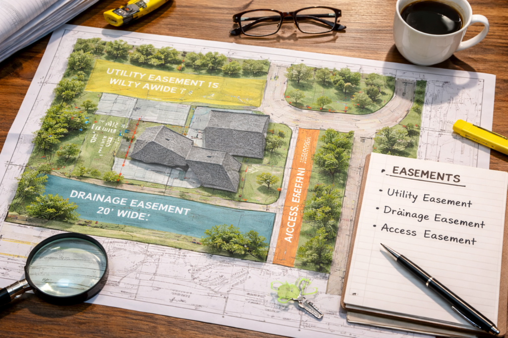
- Verify easements or rights‑of‑way. Many properties have utility lines, road easements or drainage rights that affect where fences and buildings can go. Surveys identify these restrictions so you can plan accordingly.
How boundary surveys are performed
Boundary surveys blend research with fieldwork. Here is what typically happens:
- Document research: The surveyor reviews your deed, prior surveys and county maps to understand the legal description. They may also search adjoining deeds to identify any conflicts.
- Field measurements: Surveyors visit the site with GPS receivers, total stations and measuring tapes. They locate existing monuments such as iron pins, pipes or rock cairns and measure distances and angles.
- Boundary analysis: Using the field data and deed information, the surveyor resolves discrepancies and mathematically computes the true boundary. This can involve adjusting for magnetic declination or reconciling differences between recorded bearings and actual measurements.
- Setting markers: If corners are missing or not clearly marked, the surveyor sets new monument pins or stakes. They may paint lines or flag corners for easy visibility.
- Preparing a survey plat: The final deliverable is a detailed map showing the property lines, corner markers, adjoining properties, any encroachments and legal descriptions. This document can be filed with county records or given to your contractor to guide fence placement.
Costs and what to expect
The price of a boundary survey depends on factors like lot size, terrain, availability of existing markers and complexity of deed research. Smaller suburban lots in Salt Lake City might cost a few hundred dollars, while rural acreage or properties with unclear deeds can be higher. To keep costs down:
- Provide your surveyor with any previous plats or boundary descriptions. Having older surveys speeds the research phase.
- Clear brush and yard debris so crews can access corners easily.
- Discuss your project upfront. If you intend to build a fence or addition, the surveyor can set corner stakes at visible locations.
Only licensed professionals are legally allowed to perform boundary surveys. You can verify a Utah surveyor’s license using the Division of Professional Licensing’s online lookup tool (external link). For industry standards and terminology, consult the National Society of Professional Surveyors’ guide to boundary surveys (external link).
Integrating boundary surveys with other services
Boundary surveys often lead to additional work. For instance, if you discover a creek or irrigation ditch near your property, you might need a hydrographic survey to map underwater features. Our recent article on hydrographic surveys in Utah (internal link) explains how these specialized surveys complement boundary surveys by identifying flood risks and shorelines. Likewise, a topographic survey can capture elevation data and surface features, which is useful when grading a yard or designing a retaining wall. Working with a full‑service company ensures your information remains consistent across different survey types.
Final thoughts
A boundary survey is a small investment compared to the cost of legal disputes, demolition or lost property. Don’t assume a fence or shrub row marks your line; hire a licensed surveyor to verify it. With accurate boundaries, you can build fences and structures with confidence, protect your property rights and foster good neighbor relations. If you’re unsure where to start, Cook Surveying’s team is ready to help homeowners across Utah navigate the process.