In the field of land surveying, particularly in areas like Salt Lake City, Utah, different types of surveys serve various purposes—from construction planning to legal documentation. Among these, certain surveys specifically focus on measuring land boundaries. These are essential for property transactions, resolving disputes, and ensuring proper land use. This article will explore the types of surveys primarily concerned with delineating property boundaries and their significance in the realm of real estate and land management.
Types of Surveys Focused on Land Boundaries
Boundary Surveys
Boundary surveys are the most direct approach to identifying and marking the perimeters of a property. These surveys are critical when:
- Buying or Selling Property: Ensures that the legal description matches the physical layout of the land.
- Erecting Fences or Other Structures: Helps property owners avoid encroachments that could lead to legal disputes.
Legal Descriptive Surveys
While closely related to boundary surveys, legal descriptive surveys go a step further by providing a written description of the property boundaries that is used in legal documents:
- Purpose: These surveys are often required during property transactions to supplement the legal documentation with precise measurements and boundary descriptions.
For further details on boundary and legal descriptive surveys, the National Society of Professional Surveyors provides resources and guidelines that are invaluable to both surveyors and property owners.
ALTA/NSPS Land Title Surveys
Comprehensive Property Assessment
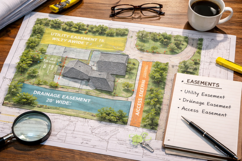
An ALTA/NSPS survey, a type of boundary survey that meets the requirements set by the American Land Title Association and the National Society of Professional Surveyors, is comprehensive and includes:
- Boundary Lines: Detailed measurement of property lines.
- Additional Features: Identification of any easements, encroachments, or other conditions affecting the property.
Purpose and Usage
- Real Estate Transactions: Particularly useful in high-value transactions where a detailed understanding of the property is crucial.
- Legal Accuracy: Provides detailed information needed for legal purposes and dispute resolutions.
For a deeper understanding of ALTA/NSPS surveys and their specifications, visiting the American Land Title Association can provide more comprehensive insights.
Site Planning Surveys
Integration of Boundary Data with Topographical Features
While primarily focused on site development, site planning surveys incorporate boundary measurements to ensure that development plans are accurate and feasible:
- Purpose: Used in the planning phase of construction projects to integrate boundary data with topographical and environmental studies.
- Application: Critical for architects and engineers in designing buildings and other structures while respecting property limits.
Conclusion:
Surveys that measure the boundaries of land are foundational to various aspects of property ownership and management in Salt Lake City, Utah. Whether you are involved in buying property, constructing on existing land, or needing detailed documentation for legal purposes, understanding which survey best fits your needs is crucial. For those seeking professional surveying services, Cook Surveying offers expertise in conducting thorough boundary surveys, ALTA/NSPS surveys, and more, ensuring accuracy and reliability in every measurement.
External Links:
- Bureau of Land Management for information on public land surveys.
- Utah Council of Land Surveyors for local surveying standards and practices.